Conchas Lake State Park Boating
Conchas Lake State Park (Click Here for Park Page)
Description: Spectacular boating on a 16,033-acre lake on the Canadian River. Coves on the lake used for picnicing. Petroglyphs viewable from boat. Popular primitive sandy shoreline boat camping is available. Greatest depth when full is 158 Ft.
At about 4,201 Ft. Elevation the lake has approximately 88 miles of shoreline. One arm extends 11 miles southwest along the Conchas River and the other northwest along the South Canadian River and Canyon for approximately 14 miles. The greatest width is approximately 2.5 miles. The widest point is on the Conchas River Arm about 4 miles west of the Dam and Central and is an area popular for water sports and windsurfing.
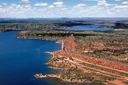 Looking north one can see the Central Campground in foreground with shoreline primitive camping, Conchas Dam is in the center which is crossed to get to North Cove, the Marina and launch ramps and at the top of the photo is the South Canadian River Arm of the lake .
Directions: About 34 miles northwest of Tucumcari.
From Albuquerque go East on I-40 about 135 miles to the NM-129 exit- Exit 300 toward Newkirk. Exit. Turn left onto NM-129. Go north about 17.5 miles. Watch for a few sharp turns in the road and narrow shoulderson this stretch. Turn right onto NM-104 and go a distance of about 6 miles. Turn slightly left onto State Road 433 N for 2.6 miles following the road directions to the state park. Watch the narrow dam top crossing.
From Las Vegas New Mexico go southeast on NM 104 for 75 miles to State Road 433 N and go 2.6 miles following the road directions into the park. Watch the narrow dam top crossing.
Map:
Printable park map (pdf) A privately made fishing and boating map is available at many marinas and boating stores statewide.
GPS Location for Park Office:
N 35.25.492 W 104.11.143
Water Sports:
Boating, swimming, water skiing, personal watercraft, windsurfing, sailing, snorkeling, scuba diving. and fishing year around. September and October are best months for flatwater kayaking with clear days and water still warm.
Special Water Events:
American Bass Anglers American Fishing Tour 15 March 08
Conditions:
-
Excellent Boating: 4,205 feet in elevation down to 4,196 feet in elevation (356,221 acre-feet down to 270,060 acre-feet storage) 10,592 surface acres down to 8,472 surface acres
-
Good Boating: 4,196 feet in elevation down to 4,165 feet in elevation ( 270,060 acre-feet down to 93,458 acre-feet in storage) 8,472 surface acres down to 3,667 surface acres
-
Fair Boating: 4,165 feet in elevation down to 4,159 feet in elevation ( 93,458 acre-feet down to 73,217 acre-feet in storage) 3,667 surface acres down to 3,116 surface acres
This lake drains a very large watershed that impacts water levels for boating quickly. For example, a set of major rainstorms in NE New Mexico will runoff to Conchas Lake and can raise levels 2-3 feet in the middle of the summer.
Ramps: 8
(Ramps open at any given time are selected based on water levels.)
North side ramps are by the marina past the State Park Office north of both the dam and the Corps of Engineers Offices. All north side ramps are 2 lane concrete.
North side #1 (Cove CG) Top Elevation: 4,186 Ft. Bottom Elevation: 4,157 Ft. North side #2 (South Facing) Top Elevation: 4,202 Ft. Bottom Elevation: 4,181 Ft. North side #3 (Cove CG) Top Elevation: 4,182 Ft. Bottom Elevation: 4,174 Ft. North side #4 (North Facing) Top Elevation: 4,202 Ft. Bottom Elevation: 4,186 Ft. North side #5 (Cove CG) Top Elevation: 4,173 Ft. Bottom Elevation: 4,155 Ft.
South side ramps are packed soil and sloping rock and are more suitable for shallow draft boats such as Personal Watercraft, some pontoon and bass boats.
South side #1 Top Elevation: 4,170 Ft. Bottom Elevation: 4,158 Ft. South side #2 Top Elevation: 4,187 Ft. Bottom Elevation: 4,177 Ft. South side #3 Top Elevation: 4,205 Ft. Bottom Elevation: 4,163 Ft.
Docks:
The 60′ and 90′ boating loading/unloading docks on the North side ramp locations are used depending on the operable ramps. South side has one 60′ old dock.
There are no parks fishing docks. Fishing is prohibited on any boat dock.
The North Dock Marina allows fishing off fuel dock and main dock area after hours only.
Marinas/Rentals:
Conchas North Dock Marina Concession Map North Dock Marina serves the lake. . Overnight mobile home rentals. Full service restaurant was closed for a while in 2007, inquire before going if you are not cooking from a camper. There is also lounge with weekend bands during most of the summer season, groceries, gas, ice etc. 868-2251 Fax (505) 868-2901
Overnight mobile home rentals
Full-service restaurant
Lounge with live music and dancing every Saturday night
Memorial Day through Labor Day
Store open year-round
Certified Mercury and OMC mechanic on duty
Overnight covered slip rentals
Prices are subject to change. Please contact New Mexico State Parks concessionaires for current fees and prices.
Wind Warning Lights:
One at Juniper Campground, One at Central Campground and One at Bell Point.
Prevailing Winds:
Current Tucumcari Conditions Prevailing are typically SW and SE. Major T-Storms are prevalent during summer coming from W and SW to NW. Waves 4-6 feet are likely on far sides of the lake. Take appropriate clothing to weather out a storm on a shoreline if necessary and a securing anchor and line.
Fish Species:
Warm water Fishery – Largemouth and smallmouth bass, bluegill, crappie, channel catfish and walleye. Tournament participants should get boat inspections done at state park office or by the marine enforcement officer prior to tournament days to avoid delays on ramp launchings.
Hunting:
Restricted and governed under the Small Game and Waterfowl Proclamation of the Game and Fish Department. Check in the annual waterfowl proclamation from the New Mexico Game and Fish. Check with the park manager forspecific restricted areas. For the 2005-2006 season…
it was open for waterfowl, Virginia rail, common snipe and sora.
Special Boating Restrictions:
Lake is closed to boating at 4,155′ Elevation.
There is a FULL “No Wake” Zone from east shore to west shore in the vicinity of the North Dock Boat Ramps to just north of the North Dock Marina and Gas Dock. No whitewater off the bow or sides of a vessel in this area. It is illegal to tow tubes thru this congested area. These restrictions are strictly enforced for safety of those fueling at the gas dock, the comfort of the marina slip owners, and for collision reduction in the loading and unloading areas. Thank you for your cooperation.
Special Note:
Water skiing of active water sports are problematic in the narrow channel segments between the Dam and Cove and North of Bell Point. Keep aware of the need to maintain a safe corridor width of 150′ as you do active water sports.
Service Boats:
North Dock Marina store has a boat repair shop and gas pumps. The on-the-water marina has a gas dock for fueling as well. Check at the gas dock for current hours. Mechanic on duty.
Recreation Areas Managed By:
New Mexico State Parks. Primitive camping on beach areas of the park are in a number of locations. Most popular locations are south of the Marina and at Central Campground. Other sites on the lake require a land status map to keep from trespassing on private property. Make sure you are aware of park regulations.
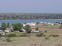
Central Campground shoreline camping
Dam Operations and shoreline developement regulations by:
Land Areas Surrounding Lake:
Many shoreline areas and docks are private. Inquire before setting out on the lake.
Information:
(505) 868-2270