Trails
Trails in New Mexico State Parks
The following are brief descriptions of selected trails at some of the 35 New Mexico State Parks. Several parks have downloadable (pdf) maps and trail guides (click on the highlighted trail name).
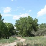
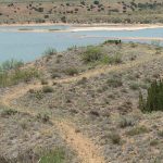
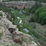 Bluewater Lake State Park
- The trail is a steep and rocky ¼-mile climb leading to Bluewater Creek. The creek is a ribbon of green riparian habitat below the dam, which offers a change of scenery from the rest of the park. The creek water level can vary and it may not be possible to cross the creek on foot.
Bottomless Lakes State Park
- The 3-mile Skidmarks Trail was built by and for mountain biking, but it’s great for hiking too!
- The ½-mile Wetlands Trail features a boardwalk to 3 wildlife viewing blinds.
- The Bluff Trail is an easy nature trail (0.86 mile) with interpretive signs.
Cerrillos Hills State Park
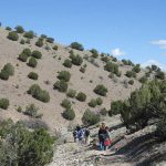 The park features 5 miles of primitive trails through the piñon-juniper hills, with views to the Ortiz Mountains and beyond. Interpretive signs are located throughout the trail system, many of which focus on the historic mines in the park. Mountain bikes and horses are welcome on the trails, and guided horseback rides are available.
Cimarron Canyon State Park
- The park provides access to trails in the Colin Neblett Wildlife Management Area. Vehicles parked at a trailhead
 must have either: a park permit; hunting or fishing license; or Department of Game and Fish GAIN permit. The Maverick Canyon Trails are old logging roads, with many unmarked intersections. These trails are not maintained by the State Parks Division.
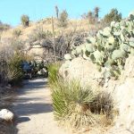
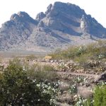
City of Rocks State Park
- The Hydra Trail is a 3.25-mile loop around the campground, with several options to create a shorter loop by returning to the campground road.
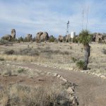 Access the trail from the visitor center or the botanical garden.
Coyote Creek State Park
- The 3/4 mile Eusebio Romero Trail takes you across the forested hillside above the creek.
The trail climbs steeply up the hill behind the group shelter and returns to the creek near campsite 24 along a gentler grade.
Eagle Nest Lake State Park
- The Lake View Trail is a relatively level, tranquil path from the park visitor center to the Village of Eagle Nest (0.41 mile) and from the Village to the Moreno Day Use Area (1.17 miles). The trail
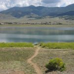 affords excellent views of wildflowers, lakeshore wildlife, and the surrounding mountains.
 - The Eagle Nest Lake multi-use trail extends 5 miles from the campground to the Cieneguilla Day Use Area.
Elephant Butte Lake State Park
- The West Lakeshore Trail is a 10-mile trail that provides panoramic views of the lake and surrounding landscape.
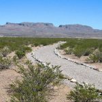 The trail can easily be hiked in shorter sections from the five trailhead parking areas between the City of Elephant Butte and the South Monticello Campground..
- The 1.5-mile Luchini Trail winds through the sand dunes between the visitor center and the campgrounds and also provides pedestrian access to the Elephant Butte Inn.
- The Paseo del Rio Trail is great for birding along the Rio Grande below the dam. The ¾-mile trail contains some interpretive signage of historic interest .
- The Dirt Dam Trail is the closed road to the Elephant Butte Dam (the dam itself is closed to public access). This easy paved route is 1.5 miles.
- Pick up a deluxe pocket trail guide with maps of all the trails at the visitor center.
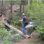
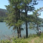
Fenton Lake State Park
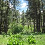 The Hal Baxter Trail – The 1-mile (one-way) trail follows the edge of the meadow and forest, along the south side of the Rio Cebolla. During the winter, use the campground road (closed to vehicles in the winter) to create a 2.3-mile loop for snowshoeing or cross-country skiing. The trail affords great views of geologic features, forest, and creek habitat, and wildlife such as beaver, elk, deer, and mountain lions.
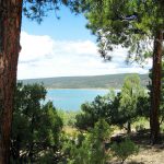
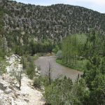
 The Rio Chama Trail – This 5-mile primitive trail that connects Heron Lake State Park to El Vado Lake State Park. At El Vado Lake, the trail begins north of the Elk Run Campground near Shale Point. From the trailhead at Heron Lake State Park, the trail starts with a wooden staircase and suspension bridge over the Rio Chama and quickly climbs into mixed conifer forest overlooking Heron Lake.
Heron Lake State Park
 The East Meadow Trail – The 2.4-mile (one way) East Meadow Trail begins at the visitor center and winds through forest and meadows, with views of the Brazos Cliffs to an overlook of the lake.
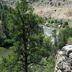
- Salmon Run Trail – The 5-mile Salmon Run Trail extends from the visitor center to the dam, passing a number of the park’s developed campgrounds as it winds through a forest of ponderosa pine and Gambel oak. The trail offers many scenic overlooks of the lake and wildlife viewing opportunities.
- Pick up a deluxe pocket trail guide with maps of the above trails at the Visitor Center.
Hyde Memorial State Park
 This park has a trail for everyone – hike to a waterfall, along a creek through a forest of aspen and pine, or climb 1000′ up to views of Santa Fe.
- Circle Trail –The west side of the Circle Trail is 2.2 miles, climbing steeply from 8,400’ to 9,440’ at its highest point, providing an excellent view of the Rio Grande Valley to the west. The east side of the Circle Trail is 1 mile, with gentler grades, linking the campground, visitor center, and Waterfall Trail.
- The Waterfall Trail is a 1/4 mile trail up a narrow, forested canyon to a spectacular waterfall.
- The Piggyback Trail follows the Little Tesuque Creek for a half mile.
Leasburg Dam State Park
 The trail system at Leasburg Dam State Park takes you through the variety of habitats found at the park, from the desert uplands to the riparian area along the Rio Grande. The Mogollon Trail along the river is ADA accessible and is an excellent place for birding.
Living Desert Zoo and Gardens State Park
 The Ocotillo Trail is a 1-mile developed trail managed by the City of Carlsbad. The trailhead is south of the visitor center on Miehls Drive.
- Walking through the zoo on the paved pathway is 1 mile.
Mesilla Valley Bosque State Park
 Approximately 2.3 miles of trail that are accompanied with a self-guided trail booklet for visitors to enjoy.
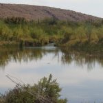
Navajo Lake State Park
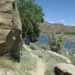 The 1.32 mile North San Juan River Trail is on the north side of the river, starting at the BLM parking area. It is a scenic walk along the river through cottonwood trees, willows, and rocky cliffs. The 1.93 mile South San Juan River Trail extends from the Crusher Hole Day Use Area to the Lower Flats Day Use Area, with an extension to Texas Hole Day Use Area.
- The newly rehabilitated BOR Trail provides access from the BOR Day Use Area to the popluar fly fishing waters of the San Juan River.
Oliver Lee Memorial State Park
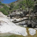 The Riparian Nature Trail starts at the visitor center, leading to the small pools of water at the mouth of Dog Canyon, and then follows the dry creek bed before heading back up to the ruins of Frenchy’s Cabin (0.5 mile). The trail provides the opportunity to view a variety of riparian vegetation, an uncommon experience in the arid desert.
- The Dog Canyon Trail begins next to the visitor center and leads to the Lincoln National Forest in a ½ mile. This difficult trail starts at 4,400’ and climbs 5 miles up the mountain to 7,600’, ending at Forest Road 90B.
Rio Grande Nature Center State Park
 The 1.7-mile network of trails between the Nature Center and the Rio Grande offers excellent birding opportunities. To ensure quality wildlife viewing, bicycles* and dogs are not permitted on the nature trails.
- *Bikes and dogs can use the Candelaria Trail through the park to the Paseo del Bosque Trail (a 16-mile paved urban trail):
Rockhound State Park
 The Rockhound unit of the park: the 0.64-mile Jasper Trail starts at the visitor center and connects to the Thunder Egg Trail (0.78 mile), which provides access to the rocky slopes overlooking the park.
- Spring Canyon: the ½ mile Lovers Leap Trail offers solitude and scenery as it climbs to a viewpoint in the Florida Mountains.
Sugarite Canyon State Park
 The park boasts nearly 13 miles of trails, offering a variety of experiences and scenery, from an old coal camp and other related mining sites to fabulous views of the watershed. The 2011 Track Fire burned fiercely in some areas of the park, but the recovery offers educational opportunities about fire science and environmental restoration to the interested visitor.
- Sugarite Canyon Trail Guide
Sumner Lake State Park
 The Discovery Trail is a 0.35-mile trail linking the visitor center and the overlook to the south.
- The Fox Run Trail is a 1.7-mile primitive trail that begins near the Eastside Campground and winds around a narrow arm of the lake.
- Also starting at the Eastside Campground or the end of the Fox Run Trail is a network of dirt roads that can be used as a trail system, especially good for bicycles (be aware of vehicles on these roads).
Ute Lake State Park
 The Ute Lake Nature Trail – This 1.75-mile network of primitive trails leads to benches at several overlooks north of the Logan Campground. The trail winds past the edge of a canyon with interesting geologic features. There are 2 picnic shelters on the trail.
Villanueva State Park
 The Viewpoint Loop Trail & El Cerro Trail – The Viewpoint Loop Trail is a rugged, 2-mile primitive trail that climbs the rocky slopes high above the Pecos River.
- The El Cerro Trail is 0.64 miles (one way) and has a more gradual climb to a view of the park from the north side of the river.
- The River Trail starts at the end of the park road and follows the edge of the river for 0.28 mile.
Bluewater Lake
Bottomless Lakes
Brantley Lake
Caballo Lake
Cerrillos Hills
Cimarron Canyon
City of Rocks State Park
Clayton Lake
Conchas Lake
Coyote Creek
Eagle Nest Lake
Elephant Butte Lake
El Vado Lake
Fenton Lake
Heron Lake
Hyde Memorial
Leasburg Dam
Living Desert Zoo & Gardens
Manzano Mountains
Mesilla Valley Bosque
Morphy Lake
Navajo Lake
Oasis
Oliver Lee Memorial
Pancho Villa
Pecos Canyon
Percha Dam
Rio Grande Nature Center
Rockhound
Santa Rosa Lake
Storrie Lake
Sugarite Canyon
Sumner Lake
Ute Lake
Villanueva
LOCATIONS
Bluewater Lake
- Park Elevation: 7,554 ft
- Click Here for More Info.
- This serene lake, located 25 miles west of Grants, is set in a pinon-juniper landscape with views towards the Zuni Mountains. The park offers camping, hiking, birding, horseback riding and fishing. And not just any fishing – you’ll find some of the best tiger muskie fishing at Bluewater Lake!
Bottomless Lakes
- Park Elevation: 3,617 ft
- Click Here for More Info.
- Located just 14 miles southeast of Roswell, Bottomless Lakes State Park is your place for bottomless fun! Enjoy non-motorized boating in your kayak or canoe, camp, fish, picnic, swim, hike, go birding or even scuba dive! The unique lakes at this park are sinkholes, ranging from 17 to 90 feet deep. The greenish-blue color created by aquatic plants is what gives the lakes the illusion of great depth.
Brantley Lake
- Park Elevation: 3,295 ft
- Click Here for More Info.
- The southernmost lake in New Mexico is an oasis of water, wildlife, plant life, gorgeous sunsets and stunning night skies. Located twelve miles North of Carlsbad, NM, the park offers boating, kayaking, canoeing, fishing, hiking trails, exceptional bird watching, developed and primitive campsites and restrooms with showers. Whether you’re picnicking for the day, or camping in your RV for a week, you’ll be sure to find adventure at Brantley Lake State Park!
Caballo Lake
- Park Elevation: 4,447 ft
- Click Here for More Info.
- Framed against the Caballo Mountains, this lake boasts an array of water recreation, such as boating, kayaking, canoeing, sailing, swimming, and fishing. Choose from 170 campsites, with plenty of sites with utility hookups for RVs. There’s just as much to do off the water while hiking, horseback riding, birding, and picnicking.
Cerrillos Hills
- Park Elevation: 5,900 - 6,100 ft
- Click Here for More Info.
- Cerrillos Hills, New Mexico's 34th State Park, is a year-round, day-use park located off the Turquoise Trail National Scenic Byway between Santa Fe and Albuquerque. You will cross paths with over 1,100 years of mining history along the five miles of trails and enjoy spectacular views of the Sandia, Ortiz, Jemez, and Sangre de Cristo Mountain Ranges.
Cimarron Canyon
- Park Elevation: 7,876 ft
- Click Here for More Info.
- The Cimarron River flows through this narrow, forested canyon, located near Eagle Nest on the Enchanted Circle Scenic Byway. The park offers beautiful views, interesting geology, quiet camping, fly fishing, hiking, and equestrian trails. The wildlife viewing opportunities are amazing, as the park sits at the center of the Colin Neblett Wildlife Management Area.
City of Rocks
- Park Elevation: 5,259 ft
- Click Here for More Info.
- City of Rocks gets its name from the incredible volcanic rock formations found here. The park encompasses a one square mile area in the scenic Chihuahuan desert region of southwestern New Mexico at an elevation of 5,200 feet. The “city” is a geologic formation made up of large, sculptured rock
columns, or pinnacles, rising as high as 40 feet and separated by paths or lanes resembling city streets.
These rocks were formed about 34.9 million years ago when a very large volcano erupted. Then, erosion over millions of years slowly formed the sculptured columns seen today, creating a stunning, otherworldly landscape.
Located about halfway between Silver City and Deming, City of Rocks offers camp sites, hiking trails, excellent mountain biking, wildlife viewing, birding, stargazing, picnic areas and a desert botanical garden. The uniquely designed, new Visitor Center includes a large display area and modern restrooms with hot showers. City of Rocks State Park is your official sponsor of adventure!
Clayton Lake
- Park Elevation: 5,186 ft
- Click Here for More Info.
- The park is an oasis in the rolling grasslands of northeastern New Mexico. Enjoy boating, picnicking, camping, fishing and hiking. Get a unique glimpse of the past when you explore one of the most extensive dinosaur trackways in North America and a close-up look at the stars at the Lake Observatory.
Conchas Lake
- Park Elevation: 4,253 ft
- Click Here for More Info.
- Just northwest of Tucumcari, this lake features secluded coves, canyons, and sandy beaches, excellent for camping, boating, and fishing. One of New Mexico’s largest lakes, you can explore the 11 miles of the Conchas River or 14 miles of the South Canadian River portions of the lake. With miles of shoreline, there is ample opportunity for hiking and birding too.
Coyote Creek
- Park Elevation: 7,667 ft
- Click Here for More Info.
- Coyote Creek State Park, about an hour southeast of Taos, is nestled in the Sangre de Cristo Mountains along a meandering stream. Enclosed by a forest of spruce and pine, the small valley displays abundant wildflowers and beautiful fall foliage. The park is ideal for fly fishing, camping, hiking, and birding.
Eagle Nest Lake
- Park Elevation: 8,196 ft
- Click Here for More Info.
- Located on the Enchanted Circle Scenic Byway, Eagle Nest Lake is surrounded by the stunning
scenery of the high mountains of the Moreno Valley. This lake is regularly stocked with trout
and salmon. Anglers can fish from the banks or by boat and ice fish in the winter.
At 8,300 feet in elevation, the park offers a cool retreat from the summer heat for fisherman,
boaters, campers, hikers, and wildlife enthusiasts. An abundance of animals makes Eagle Nest Lake an ideal location for wildlife viewing.
El Vado Lake
- Park Elevation: 7,209 ft
- Click Here for More Info.
- Located in New Mexico’s northern mountains, El Vado Lake State Park offers fishing, boating, camping, hiking, winter cross-country skiing, and snowshoeing. A 5.5-mile scenic trail along the Rio Chama connects El Vado with nearby Heron Lake. Quiet coves around the lake are great places to catch trout and kokanee salmon. The lake and surrounding area are a major wintering ground for bald eagles and other birds.
Elephant Butte Lake
- Park Elevation: 4,527 ft
- Click Here for More Info.
- If you like camping, fishing, boating, or just being outdoors, Elephant Butte is for you. There
is plenty of water and plenty of beach room at New Mexico's largest State Park. Elephant Butte Lake can accommodate watercraft of many styles and sizes: kayaks, jet skis,
pontoons, sailboats, ski boats, cruisers, and houseboats. Remember to wear your life jacket.
Boat safe and boat smart! Besides sandy beaches, the State Park offers restrooms, picnic area, playgrounds, and developed sites with electric and water hook-ups for RV's.
Fenton Lake
- Park Elevation: 7,650 ft
- Click Here for More Info.
- The Jemez Mountains provide the backdrop for this stunning year-round retreat surrounded by
beautiful ponderosa pine forests. Fenton Lake State Park is a mellow mountain escape. The Rio Cebolla flows through the park and the lake provides an opportunity to fish and canoe. The park also attracts campers, hikers, and cross-country skiers. There is even a fun playground for the kids.
Stocked with rainbow trout from fall through spring, the lake is home to German brown trout, and is an ideal spot for flyfishing. Although most anglers prefer the warmth and comfort of summer, there is also winter ice fishing.
Heron Lake
- Park Elevation: 7,167 ft
- Click Here for More Info.
- A picturesque lake set among the tall pines of northern New Mexico, Heron Lake State Park has been designated a “quiet lake” where boats operate at no-wake speeds only, making it an excellent location for all types of paddle craft. Heron Lake also has amazing sailing, cross-country skiing, and hiking. The park is a fisherperson's paradise with record-size trout and kokanee salmon. Ice fishing is very popular in winter. Several campgrounds line the shore of this scenic lake with primitive and developed campsites are available for every taste.
Hyde Memorial
- Park Elevation: 8,300 - 9,400 ft
- Click Here for More Info.
- New Mexico’s first State Park is set in the Sangre de Cristo Mountains pine forest, along Little Tesuque Creek. The park is a short drive from Santa Fe and offers excellent group facilities and campsites. There are beautiful hiking trails with spectacular views. You can enjoy Hyde Memorial State Park in the winter months too with snowshoeing, sledding, and cross-country skiing opportunities available.
Hyde Memorial State Park is the perfect location for your next wedding, family reunion, or yurt adventure!
*Wifi available at Visitor Center
Leasburg Dam
- Park Elevation: 3,962 ft
- Click Here for More Info.
- A short 25 minute drive from bustling Las Cruces brings you to this quiet park along the Rio Grande. Leasburg Dam State Park offers peace and relaxation, a beautiful cactus garden, several hiking trails, and opportunities for fishing, canoeing, kayaking and birding. Night sky programs are very popular at this park, which features an observatory.
Living Desert Zoo & Gardens
- Park Elevation: 3,482 ft
- Click Here for More Info.
- This native wildlife zoo, accredited by the Association of Zoos and Aquariums, exhibits more than 40 species of animals and hundreds of species of plants native to the Chihuahuan Desert. The park provides an up-close experience for visitors, with a variety of fun interpretive programs for every season geared for the entire family. Living Desert also has beautiful hiking trails, picnic areas and group facilities. There is no camping and no pets are allowed.
Manzano Mountains
- Park Elevation: 7,250 ft
- Click Here for More Info.
- Manzano Mountains State Park is an excellent destination for hiking and camping. Nestled in the wooded foothills of the Manzanos, this park provides a quiet retreat and is a nice family get-away. Wildlife viewing, birding and photography are great activities at this park.
Mesilla Valley Bosque
- Park Elevation: 3,879 ft
- Click Here for More Info.
- The park is located on the Rio Grande near Las Cruces and 1.5 miles from historic Mesilla. Visitors have many opportunities to view wildlife in natural surroundings while strolling one of the self-guided nature trails. Enjoy a fun ranger-led tour!
Morphy Lake
- Park Elevation: 7,953 ft
- Click Here for More Info.
- Nestled in the Sangre de Cristo Mountains at 8,000 feet in elevation, this hidden lake sits at the edge of the Pecos Wilderness. The lake is stocked with rainbow trout and offers excellent fishing. Canoeing is also a popular activity and this pristine scenic spot offers a unique opportunity for primitive camping. Due to parking and campsite size limitations, maximum RV length allowed is 18 feet.
Navajo Lake
- Park Elevation: 5,600 – 6,600 ft
- Click Here for More Info.
- Navajo Lake is the second largest lake in the state, with multiple campgrounds, two marinas, and two boat docks. Navajo is a haven for boaters of every stripe – motorized boaters, canoers, kayakers, water skiers and sailors. The San Juan River is a world-class fly fishing destination and features a campground, day use areas and a serene trail along the river. Navajo Lake State Park offers some of the best boating, fishing, hiking, and camping in New Mexico.
Oasis
- Park Elevation: 4,058 ft
- Click Here for More Info.
- You’ll find this true oasis just north of Portales, NM. Oasis State Park is set among cottonwood trees, shifting sand dunes, and a small fishing lake. Although fishing is the park’s main draw, it also has several hiking trails, a peaceful and shady campground, and an abundance of birds.
Oliver Lee Memorial
- Park Elevation: 4,400 ft
- Click Here for More Info.
- Set against the dramatic Sacramento Mountains, this park features a historic ranch house, quiet camping in the Chihuahuan Desert, and the unique oasis of pools of water under the cottonwood trees of Dog Canyon. Enjoy a short walk on the Riparian Nature Trail or a challenging hike up the Dog Canyon Trail
Pancho Villa
- Park Elevation: 4,073 ft
- Click Here for More Info.
- Located at the border of Mexico, the park exhibit hall and historic structures capture the history of the Pancho Villa Raid and historic Camp Furlong. The large campground offers utility hookups for campers with RVs, and a playground for the kids.
Pecos Canyon
- Park Elevation: 7,628 feet to 8,196 ft
- Click Here for More Info.
-
Pecos Canyon, New Mexico’s 35th state park, is a jewel near the Pecos Wilderness of the Sangre de Cristo Mountains in north central New Mexico.
Just a short drive from Santa Fe and north of the Village of Pecos, this newly created state park is currently under development and will offer fishing, camping, hiking and more!
Percha Dam
- Park Elevation: 4,447 ft
- Click Here for More Info.
- This quiet park along the Rio Grande is shaded by tall cottonwoods and provides excellent fishing, relaxing camping, and outstanding bird watching.
Rio Grande Nature Center
- Park Elevation: 4,968 ft
- Click Here for More Info.
- Located on the Rio Grande flyway, the park offers excellent birdwatching opportunities throughout the year. There are indoor and outdoor wildlife viewing areas overlooking ponds, a native plant garden, and a pollinator garden as well as access to the city-managed trails to the Rio Grande and Bosque. The Visitor Center offers informative displays and a unique Nature Shop. The park is day-use only, no camping. Leashed pets are allowed in the parking area and on the adjacent city trails only.
Rockhound
- Park Elevation: 4,520 - 5,400 ft
- Click Here for More Info.
- The rugged slopes of the Little Florida Mountains are the setting for this park, which boasts trails, unique geology, wildflower displays, and a peaceful campground. The stunning scenery of the Spring Canyon unit of the park provides a peaceful area for hiking or picnicking.
Santa Rosa
- Park Elevation: 4,751 ft
- Click Here for More Info.
- This reservoir on the plains of eastern New Mexico offers fishing, boating, camping and hiking, as well as abundant bird watching opportunities. Equestrians are welcome at the Los Tanos Campground.
Storrie Lake
- Park Elevation: 6,607 ft
- Click Here for More Info.
- This serene lake offers great opportunities for fishing, bird watching, and windsurfing. Choose from a variety of campsites with utility hookups for RVs.
The park is conveniently located near historic Las Vegas.
Sugarite Canyon
- Park Elevation: 6,664 ft
- Click Here for More Info.
- The nature enthusiast will appreciate the abundance of wildlife, birds, butterflies, and wildflowers among the lakes, creeks, forests, and meadows. Nearly all outdoor recreation activities are possible: Fishing, boating, hiking, horseback riding, hunting, and camping.
Sumner Lake
- Park Elevation: 4,310 ft
- Click Here for More Info.
- This lake on the grassy plains offers many activities, such as boating, swimming, fishing, wildlife viewing, and birding. Relax at a campsite with views of the lake after a hike along the lakeshore.
Ute Lake
- Park Elevation: 3,762 ft
- Click Here for More Info.
- This reservoir on the Canadian River is one of the longest lakes in the state at nearly 13 miles, and boasts a variety of fun water sports. The campgrounds offer a variety of camping experiences, including the Yucca Campground, designed for RVs.
Villanueva
- Park Elevation: 6,110 ft
- Click Here for More Info.
- The park is nestled between high sandstone bluffs that form a canyon along the Pecos River. Camp or picnic under the shade of cottonwood trees. Enjoy fishing, birding, wildflower viewing, or hiking the trails along the canyon walls.