Navajo Lake State Park Boating

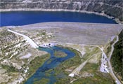
Description: Popular but uncrowded 15,600-acre lake with a depth at the deepest part close to the dam of almost 400 feet. Three major arms of the lake, the Pine, the San Juan, and Francis gives cruising boaters plenty to enjoy. The river from the base of dam has a world famous stretch of trout fishing and drift boat run on the San Juan River. Great overnight primitive camping in sheltered coves and arms on this lake. Below the dam is the start of the Class II river run of the San Juan River. Rental boats available at the marina (see information below).
Directions: Forty miles east of Farmington. From Albuquerque go north about 16 miles to Exit 242 At end of exit turn left onto US 550 N and go 152 miles to Bloomfield, New Mexico. Go 25 miles east of Bloomfield via US 64 and NM 511 and NM 539 to Navajo Dam.
GPS Coordinates:
(note all GPS coordinates are general location reference only and not to be used for boat navigation purposes)
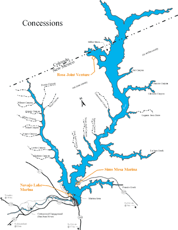
Main Marina–
Latitude = 36.8170, Longitude = -107.6142
Lat = 36 degrees, 49.0 minutes North Long = 107 degrees, 36.9 minutes West
Sims Marina–
Latitude = 36.8296, Longitude = -107.5925
Lat = 36 degrees, 49.8 minutes North Long = 107 degrees, 35.6 minutes West
Lat = 36 degrees, 49 minutes, 4 seconds Long = 107 degrees, 35 minutes, 16 seconds
Colorado Cove–
Latitude = 36.8479, Longitude = -107.5783
Lat = 36 degrees, 50.9 minutes North Long = 107 degrees, 34.7 minutes West
Lat = 36 degrees, 50 minutes, 30.12 seconds Long=107degrees, 35 minutes, 23.27 seconds
“S” Curves–
Latitude = 36.8820, Longitude = -107.5036
Lat = 36 degrees, 52.9 minutes North Long = 107 degrees, 30.2 minutes West
Lat = 36 degrees, 52 minutes, 55 seconds Long = 107 degrees, 30 minutes, 12 seconds
Francis Canyon–
Latitude = 36.8142, Longitude = -107.5874
Lat = 36 degrees, 48.9 minutes North Long = 107 degrees, 35.2 minutes West
Pine Arm–
Latitude = 36.8346, Longitude = -107.6114
Water Sports:
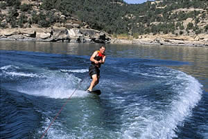
Boating including cruising, houseboating, driftboating, paddlesports, swimming, water skiing, jet skiing, sailing, diving, and fishing including fantastic salmon snagging in the fall.
Special Water Events:
American Bass Anglers American Fishing Tour.
Conditions:
- Excellent Boating: 6,102.0 feet in elevation down to 6,053 feet in elevation ( 1,985,800 acre-feet down to 1,261,200 acre-feet storage) 13,000 surface acres down to 12,500 surface acres approx.
- Good Boating: 6,053 feet in elevation down to 6,030 feet in elevation (1,261,200 acre-feet down to 1,008,600 acre-feet storage) 12,500 surface acres down to 11,000 surface acres approx.
-
Fair Boating: 6,030 feet in elevation down to 5,999 feet in elevation (1,008,600 acre-feet down to 730,830 acre-feet in storage) 11,000 surface acres down to 8,000 surface acres approx.
Ramps: 3
- One (1) concrete ramp located at Sims Mesa with three (3) launching Lanes. Top elevation: 6,199 Ft. Bottom elevation: 6,000 Ft.
- One (1) concrete ramp located at the Pine Recreation Area with six (6) launching lanes. Top elevation: 6,101 Ft. Bottom elevation: 5,997 Ft.
Docks: 3
- One (1) 10’ x 60’ Meeco Courtesy Dock with Trex decking located at Sims Mesa.
- Two (2) 10’ x 90’ Meeco Courtesy Dock with Trex decking located at the Pine Recreation Area.
River Running:
Navajo Lake State Park to Blanco River Run.
Drift boats for fishing are popular for a Class I/II sixteen mile run on the San Juan River from access points below dam through the state park to Blanco most of the year. Put in for drift boat use is for fishing only below the dam. Other paddle craft only activities are prohibited by regulation. However you can canoe or kayak on this stretch of the river as long as fishing also takes place. Just carry your rod and reel and fishing permit. Be careful to respect the fishing activity along this stretch of the river. This restricted area runs to the park boundary just below the pump house . A good idea for a fun trip would be to put in below the dam in the early afternoon and run to Cottonwood Campground and stay overnight and continue on the rest of the trip the next day.
(FYI Beyond the Navajo Lake State Park to Blanco River Run section, the Blanco to Shiprock San Juan River section has two diversion dams that must be portaged. From Shiprock to Four Corners, the San Juan river is calm except for some sand waves in higher water, taking boaters past sandstone bluffs and badlands into Utah. Once into Utah, one can make a multi-day trip all the way to the Colorado River, passing such historical areas like Bluff and Mexican Hat. The river low conditions for that stretch is below 800 cfs. Very high conditions beyond Bluff can reach 6,000 cfs.)
Note: The river channel in the Park has changed.
A one-quarter mile stretch of the San Juan River below Navajo Dam has a new look since boulders were placed in the river to improve trout fishing.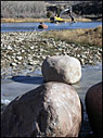 This is also will make some runs in the channel different for drift boats as well.
State Parks worked with the New Mexico Department of Game and Fish to remove sediment from Rex Smith Wash and from the riverbed at Kiddie Hole, where the wash enters the river.
State Parks and Game and Fish staff, along with members of the public, are concerned about impacts from sediment accumulation in popular fishing areas along the San Juan,” State Parks will evaluate long-term alternatives as part of the park’s new management plan.
Heavy sediment build-up, composed of cobbles and sand, has accumulated at Kiddie Hole and at other points along the “blue ribbon” stretch of the San Juan River within Navajo Lake State Park. The build-up is caused by a combination of natural processes and human disturbances/factors such as oil/gas exploration/development and Off Highway Vehicle use.
Removal of sediment from Rex Smith Wash will prevent some sediment from entering the river; sediment removed from Kiddie Hole itself will deepen the river and increase flow in this section, improving aquatic habitat.
The Texas Hole – the most popular and famous fishing spot on the stretch of the San Juan River within the park – is located about one mile west of Navajo Dam. Kiddie Hole is located just upstream and east of the Texas Hole parking lot.
San Juan River Conditions:
San Juan River Run below Dam (Stream gage data for Below SR 173 at Archuleta, NM).
Drift boat run is just ok on the short run below the dam when the water is running at a minimum of 250 cfs.
A Class I run will find 500 cfs good.
Canoes, kayaks and pedalcraft with Mirage drive will find great conditions to Class II at 900 cfs.
Marinas/Rentals:
Navajo Dam Marina (505) 632-3245/(800) 582-5687
Fax (505) 632-5345
navajomarina.com
Navajo Lake Marina is the largest full-service marina operating on Navajo Lake Reservoir. The Marina is located on the south end of Navajo Lake State Park on N.M. 511. We are 45 miles northeast of Farmington, N.M. and 50 miles southeast of Durango, Colo.
The Marina is owned and operated by Navajo Dam Enterprises Inc., and offers a full service store and tackle shop, full-service fueling facility, boat rentals, slip and buoy rentals, dry storage facilities and public sewer pump-out facilities. It also features a dining establishment the Galley, offering gourmet pizzas. A boat repair service and lake fishing guide service also operate out of the Marina. For further information or to make boat rental reservations contact the marina at: www.navajomarina.com or 505-632-3245
- Sims Lake Marina
POB 6598
Navajo Dam, NM 87419
General Store: (505) 320-0885
Latitude = 36.8296, Longitude = -107.5925
Lat = 36 degrees, 49.8 minutes North Long = 107 degrees, 35.6 minutes West
- Two Rivers Marina aka “Arboles” Colorado Side Marina Phone 970-883-2343.
Colorado also has a marina on their side of the Main Arm, 35 miles up, called the Two Rivers Marina in Navajo State Park Colorado. it is accessed from Ignacio, Colorado and east toward Arboles by the Piedra River. It normally operates from 7 am to 7 pm from March to November. Owned by the State of Colorado, it is managed by Neal Dennis. The web site is www.parks.state.co.us and click on Navajo. Services seasonally only are: Fuel, slips, mooring balls, store with boat accessories and snacks, and a restroom on the water. They do not do service work other than battery boosts. There is however a marine service store 2 miles away. They have 4 ribbed concrete ramp lanes that extend all the way to the river channel bottom and two 150′ long courtesy docks.
Wind Warning Lights:
At Pine Site, Sims Mesa and Miller Mesa
Prevailing Winds:
Summer storms generally come out of the west. North- south arms and coves allow boaters out on the lake to hunker down to escape major storms. Occasionally a severe storm will be seen coming out of the northeast. Those storms can generate major waves at the Pine Marina making it very difficult to load a boat without damage or personal injury. In those instances it is better to go to the lee side of the lake and anchor/idle out until the storm passes.
Fish Species:
Rainbow trout, kokanee salmon, brown trout, largemouth and smallmouth bass, channel catfish, crappie, bluegill and northern pike.
Salmon snagging takes place along the shoreline during a specified fall season using weighted treble hooks.
On the San Juan River, fishing is usually done with a two fly pattern with a fly-fisherman’s “bobber” yarn or “strike indicator”. State Parks often holds programs at Cottonwood Campground with a specialist in aquatic biology of the river that can show you the food found in the fish and the best matching flys.
On the Lake shore anglers usually have success with power baits and those trolling on the lake use jointed artificial baits and other crank baits.
Fishing Guides:
The following guides are insured and registered with New Mexico for providing services within New Mexico Navajo Lake State Park for San Juan Fishing Easement: Roughrider Guide Service, Wit’s End Guest Ranch and Resort Colorado Trails Ranch, Jude Duran Customflys, The Caddis Company, Jerry’s Guide Service, Four Corners Guide Service, Rizuto’s, Inc., Cottonwood Anglers, Anasazi Anglers, Inc., Mike Crowley Mountain States Guide Service, Southwest Fly Fishers, LLC Resolution Guide Service, Animas Valley Anglers, High Plains Anglers, Duranglers, Inc., Sandstone Anglers, Inc., Arcom Outfitters, Float ‘N Fish, LLC Fishead, Born ‘N Raised, Inc. Rise ‘N Fly Guide, Lloyd W. Rogers Guide Service, Blue Sky Flyfishing Co., Soaring Eagle Lodge, LLC Outwest Anglers, Rocky Mountain Anglers, Inc. Don Oliver Fishing Guide, San Juan Troutfitters, Chama Angler, Andy Kim’s Fly Fishing, San Juan River Outfitters
Hunting Considerations:
Open seasonally for waterfowl, Viginia Rail and Common Snipe.
Special San Juan River Boating Restrictions:
Lake: None for lake but see San Juan River restrictions that follow. This lake at night is difficult to travel due to twisting lake arms and “S” curves. It is recommended that captains doing extended travel on this lake toward evening carry and mark way points with a GPS.
River: New Mexico State Parks Regulation 16.6 : Regarding the San Juan River: Motorized vessels are prohibited on the San Juan River, within Navajo State Park.
The Commercial Use of Vessels on the San Juan River within Navajo Lake State Park is authorized from the San Juan Day Use Area (Texas Hole) downstream and is limited to the purpose of fishing unless otherwise authorized by the Director. (This restriction does not apply to recreational non-commercial floating/canoeing/kayaking as long as one person has the appropriate fishing license and rod/reel. Please exercise courtesy, try not to do any trips out into the water from your boat and keep your voices low.)
Recreation Areas Managed By:
New Mexico State Parks
Land Status:
Much of the area just outside of the park boundary which follows much of the land of the entire coast is State and Federally owned. Overnight on the water is subject to primitive camping fees paid to Navajo Lake State Park. State Regulations apply for this primitive boat camping and is strictly enforced
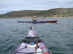 Sea Kayaking on Navajo Lake with Marcel Bieg San Juan Community College
Dam:
Operated by US Bureau of Reclamation. Lake waters are the primary storage for the Navajo Indian Irrigation Project (NAPI).
Information:
Marine Enforcement Officer, Phone; (505)632-2278 ,
Fax;(505)632-8159
Boating Emergencies:
Channel 16 is monitored by the Marina Store and relays information to the park rangers. Be aware that cell phone service is spotty on the lake and VHF radio may not carry out of some canyons at all. It is advised that you carry a Personal Location Beacon system when possible and fdo ile a Float Plan when going out on the lake.
Others emergencies requiring State Police:
Communication Centers number is 505- 334-6622.