Eagle Nest Lake State Park Boating
Eagle Nest Lake – (Click here for Park Page)
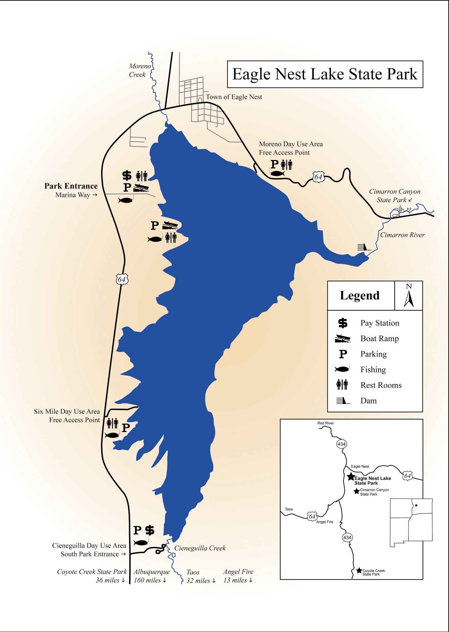
Description: Beautiful 2,000-acre (when full) lake in a wide valley surrounded by the mountains of the old west. Miles of shoreline 16.5. Maximum depth is about 90′. Length 4 miles width 1 mile. A new campground with pull in and pull thru sites with one vault toilet and individual site covered picnic tables was installed in 2009. Most all have great lake views and are within walking distance to the water.
Directions: About 35 miles east of Taos, New Mexico on the Enchanted Circle Driving Loop.
It is about a 3 hour drive from Albuquerque and 163 miles. From Albuquerque take I-25 North for 57 miles toward Santa Fe. Merge onto US-285 N / US-84 N via EXIT 282 toward LOS ALAMOS / TAOS / SANTA FE – PLAZA and go thru Santa Fe and up to Espanola for about 28.5 miles. In Espanola stay straight through town and onto NM-68 North for 43 miles to the outskirts of Taos. Turn right before the main section of Taos onto US-64 Bypass/ NM-585/ Paseo del Canon Blvd. for 2.1 miles. At the intersection turn right and travel 28 miles on the scenic but twisting road to Flechado Pass and down the twisty side to the Eagle Nest valley taking care for the Olympic cycle teams who often train in the area. The road will pass the turnoff for Vietnam Veterans Memorial State Park, the turnoff for Angel Fire Community, and shortly thereafter to the right turn east down a dirt road to the park entrance at #42 Marina Way. One mile further is the town of Eagle Nest.
GPS Coordinates for Park Entrance:
Water Sports:
Most popular for boating and fishing. Day use fees apply. Due to cold-water temperatures, swimming, water skiing, jet skiing and windsurfing are not recommended. Kayak or canoe users should always be prepared for cold water immersion. In other words dress for the swim, always wear a life jacket on this lake, and travel in pairs for assisted rescue. Test your gear in cold water and train in both assisted and self-rescue techniques. Icefishing is available in season.
Conditions:
- Excellent Boating From 8,200 feet in elevation down to 8,110 feet in elevation (94,445 acre-feet down to 86,586 acre-feet)
- Good Boating From 8,110 feet in elevation down to 8,102 feet in elevation (28,925 acre-feet down to 19,719 acre-feet)
- Fair Boating Under 8,102 feet in elevation. (19,719 acre-feet)
Ramps: 2
Main Ramp Three concrete lanes by the Visitor’s Center
Top Elevation 8,233 feet Bottom Elevation 8,206 feet
South Ramp Four concrete lanes at the South Parking Area.
Top Elevation 8,236 feet Bottom elevation 8,102 feet
Docks: 3
Two public courtesy docks at the South Ramp (with 10 minute loading/unloading limits)
One public courtesy dock at the Main Ramp near the Visitor’s Center
Fishing Guides:
Several are available, inquire at the Visitor’s Center for contact information.
Prevailing Winds:
Out of southwest . Strong waves from PM winds are common and can come directly out from the east (hot plains air rises to mountains) causing waves that can enter from the stern while launching or retrieving. Boaters wait out the weather by the dam due to the shelter in the cove but shoreline is rocky and not beachable in that area. Accidents typically occur from small craft capsizing in waves by not waiting it out.
Fish Species:
High quality cold water fishery. Kokanee Salmon, rainbow trout, nothern pike and yellow perch. Blue-Green algae prevalent during summer months
Special Boating Restrictions:
Boating and fishing activities restricted to park day-use hours 6am to 9pm only.
West shoreline has several peninsulas that stick out as the water goes down.
Service for Boats:
Motor problems are not uncommon. Plugs are fouled from low trolling speeds. Fuel can be purchased at the in Eagles Nest, a 4 mile roundtrip. Angel Fire is also used, an 18 mile round trip.
Recreation Areas Managed By:
New Mexico State Parks. No overnight boat primitive camping.
Lake Information (Land Status, Dam Operator):
Formerly owned by CS Cattle Co. of Cimarron NM. Water is controlled by State Engineers Office. Ranchers and farmers below the lake use the water for irrigation. Dam is operated by Interstate Stream Commission
District VII – Cimarron
Tim Farmer, District Supervisor
(Clayton, Tucumcari and Canadian River underground water basins and basin surface rights)
PO Box 481
301 East 9th Street
Cimarron, NM 87714
(575) 376-2918
Information:
(505) 377-1594